Monday, July 23, 2012

Seeking The Peak, Mt Washington 7/21/12

Karen, Peter & I celebrate on the summit of Mt Washington


Ok, let's get the negatives out of the way:
Yes, we waited on line to snap our summit picture. 
Yes the summit of Mount Washington is a melting-pot of people , some  more suited to a mall than a high mountain peak and  the others representing a cross section of folks frequenting auto rest areas, train stations or hiker conclaves. 
Wait in line for your summit shot (image by Peter Noonan)

Now for the rest of the story:

Forward:

7:30am on a crisp & clear Saturday morning my wife Karen, Peter Noonan and I pull into the Ammonoosuc Ravine trail head parking lot, where we plan to ascend the mountain via the Ammonoosuc Ravine Trail.  Many folks are already hiking and more are pulling in, as it's the day of the annual Mt. Washington Observatories big fundraiser "Seek The Peak", where over 500 people raise money for the Mt Washington Observatory and hike to the summit of Washington, then congregate  at the base of the Auto road for a fun catered after-party.

Karen must be a little apprehensive as it's her first attempt to summit Washington's 6,288 foot peak, the jewel of the White Mountains.  She has been at higher altitudes out west, but this will be her most ambitious hike to date. At 7:35 our boots are laced, packs are secured and we begin what is to become an epic journey, in more ways than one.  The uniqueness of trekking up Mount Washington is it's ability to combine breathtaking & unrivaled natural beauty, with a sense of history, science, tourism, surrealism and the potential at any time for weather unlike any anywhere.

Chapter 1: Breathtaking Beauty


Gem Pool
 

   The Ammonoosuc Ravine Trail begins a very generous grade through pretty wooded and stream-lined trails and paths. The incline is forgiving but the footing a little rugged.  At about the 1 mile mark small water-falls and streams can be seen. The sound of rushing water is your companion and a cooling mist of H2O can be felt as you proceed.  Then, at a little over 2  miles, as you head up a mellow rise, a magnificent waterfall and pool appear, seemingly out of nowhere.  For obvious reasons, this "gem" of a pool is known as the Gem Pool.  The crystal clear clarity of the water is astonishing.  Peter and I get there first, we've both been to and seen this little slice of heaven before.  About a minute later Karen arrives, her eyes widen and she quietly blurts out the words "Ohh Wow!"  We stop for a snack. More hikers arrive, "Ohh Wow".

Group shot taken by a fellow hiker who happens to live in Gilford

Amazing views right into Canada on a pristine day
 Now the real fun begins.  The next 2 miles or so is a very steep incline, heading up and around the Gem Pool Waterfall.  The footing is sharp, rocky and rugged, sweat pours from every pore in your body as each step is a fight against gravity. As you climb up and around the waterfall,  an occasional trail off-shoot affords you some intimate views from different elevations and angles. There is a sharp turn in the trail and you begin to head up relatively steep ledge, requiring hand and foot maneuvers to climb certain areas.   This brings you out to a series of waterfalls whose beauty are one of the things that just makes you shake your head and say "Holy sh#*!".  If you shake your head a full 180 degrees, you will be privy to a magical panoramic view of the White Mountains that on a clear day, like the one we were experiencing, affords you the ability to see right into Canada!  But, also keep an eye out to your left as, in full view, after the whistle blows it's unique wail,  the Cog Railroad appears, as it heads up a ridiculously steep ridge and disappears behind the jagged mountainside.  This place, where we stand is a wonder of our world.  Now, we meet up with some folks who happen to live not even a mile from my house in Gilford, unknown neighbors.  The Gilford girl  is a portrait photographer, she snaps our photograph. 

But enough of that sightseeing stuff, we have some more climbing to do, before taking a little break at the Lake of The Clouds hut. Approaching the hut you can't help but notice the amazing landscape which includes the Mt. Washington summit to our left and the summit of Mt. Monroe to the right, sitting basically at the hut's doorstep.  As we head into the hut, Peter hopes they didn't run out of lemonade.  They didn't, Peter's happy!

In the hut we meet a couple of through-hikers and some nice folks from Vermont, who recently climbed Katahdin.  We discuss Katadhin, the guy tells us it was one of the toughest climbs he's done, we tell them we are heading there in a couple of weeks.  He predicts we won't be disappointed.  Off they go to summit Monroe before heading on to Washington. Pete and I have done that before.  Karen is focused on getting up Washington, so we forgo Monroe.


Lake of the Clouds with the Lake of the Clouds Hut behind

The Hut break ends,  "only" 1.4 miles to go to the summit of  Washington.  They don't call  Mt Washington "The Rock Pile" for nothing.  The next 1.4 miles will bring us up a relatively steep, but a not killer  upward slope of  broken & jagged rock,created and  layed to rest by millions of years of battering wind, rain, snow and ice, referred to by many as the worst weather in the world. But before we get into that we pass The Lake of The Clouds, a beautiful mountain lake resting between Mt's Monroe & Washington..  


I posted the attached picture of the lake on facebook and someone commented, "It's not a lake, it's a giant mirror!"  I mirror that thought!

The approach to the summit of Washington from lake of The Clouds (image by Peter Noonan)
As we pass the lake and some interesting weather gear situated across from the lake, we begin the ascent toward the Summit of Washington.  A very tired and beaten sign warns us we are entering an area known for the worst weather on earth. In both directions young, strong Sherpa-like Appalachian Mountain Club (AMC) employees cross our path. They are carrying huge, heavy and awkward wooden-framed packs, loaded with supplies, trash and big boxes, destined to be received at either the hut or the Mt Washington summit complex.  Again I notice the sweat beginning to flow.  The only sounds marking my steps  are the clicking and clacking of my aluminum hiking sticks scraping the rock below and my deliberate attempt to maximize my intake of oxygen  by exaggerating each breath.  As we get closer to the summit, towers of weather and communication gear begin to appear.. larger and larger, combined with the rocky surface and eerie weather patterns swirling in and out, (seemingly coming from nowhere) and the dizzying effects of fatigue, the feel becomes sort of hyponotic and surreal, like you are walking  toward some sort of science fictitious inter-planetary outpost.  Then you pop out onto the summit complex grounds and immediately begin mingling with all sorts of people; people  in-shape, out of shape, children, babies, grandmothers ,dogs and  fellow hikers.. car, motorcycle & train tourists, clad in things like kilts, jeans, expensive hiking gear, expensive motorcycle gear, regular shorts, tight shorts and tee-shirts that say things like Northface, Seek The Peek, Harley Davidson , Dale Earnhardt, Red Sox, Yankees or Old Orchard Beach.  It really is an eerie, Dream-like feeling.  We make our way to the summit marker, stand in line behind a guy, a hiker. wearing a white wifebeater tee-shirt & sporting an old tattoo that I didn't bother to look at. He can't find his  dog, so I tell him to go look for it and I'll hold his postion in the summit picture line.  When he and his dog return he tells me he just completed his 48th 4,000 footer, we congratulate him.  I snap his picture, he snaps ours and off we go to the combination observatory/snack bar/gift shop/museum/hiker enclave for some food and rest.

Chapter 2:  The Summit

The 3 of us eat, Karen buys a slice of pizza & a Snickers bar to celebrate her well earned summit achievement.  She's worked hard on both the treadmill and the trails preparing for this.  Peter comes back with a slice of peperoni pizza, hot dog, bag of chips and a cola ( i can write a blog on that someday!).  I eat my homemade pinto bean & chipole peeper hummus wrap and buy a cup of tomato soup.  We finish up, separate the recyclables from the other trash, fill our empty water bottles with the coldest best tasting water on the planet and off we go to start our decent.  It is now 12:30 pm.

Chapter 3:  The Decent
Goofing with the Cog (image by Petwer Noonan)
We decide to descend the mountain via the Jewell Trail.  This trail is a longer (abut 5 miles) option than others and as it winds down the mountain it treats you to fantastic views of The Great Gulf and the northern Prezi's (Clay, Jefferson, Madison & Adams).  But before we leave, we sight-see and goof around a little.  I ham-up a hitchhiking photo-op with the Cog (thanks Dan for the idea), which brings out cameras and smiles to those riding the train.  We pass the grave marker of Lize Bourne, the first woman to die on Mt Washington, and Peter & I compete to see who can get the best poser-money-shot.  Below are the 2 finalist poser shots, I am partial to the one with me in it.  However, I took the other one, so it's a win-win.:


Poser shot #1 (image by Peter Noonan)


Poser shot #2
Here's where it got a little interesting. I will let Karen tell this part of the story as she posted it perfectly on Facebook:

"We encountered the two women  at 12:30pm yesterday as we were beginning our hike down Mt Washington. They came up on the cog railroad and decided it was a lovely day for a hike down the mountain. In preparation for their 3.5 hour hike down they had nothing. Not one bottle of water, no food, no backpack, no polls and apparently no cell phone. Neil did advise them that it was a difficult 5 mile hike and that there were some very steep parts but they decided to hike anyway. Since only one woman was rescued I can only assume the other woman was smart enough to turn back at some point. Luckily she was not injured and nobody that was forced to rescue her was injured either. Trust me, they were not given any bad hiking advise. They were just stupid."

Attached is the link to the rescue article, which we weren't surprised to see on the next mornings news: 
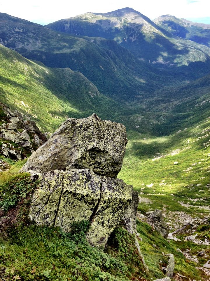
View of great Gulf, Jefferson, Madison & Adams

Karen bids farewll to the summit of Washington
Chapter 4:  The After Party
The 3 of us descend, following the beautiful Jewell trail, following ruggid switchbacks and narrow trails from above treeline, into the trees.  when the terrain became a little more hospitable, i decided to do a little trail running. We finally pop out of the woods at the Cog Railway base station and with that step, Karen officially notches her first assent of Mt Washington.  We hoof it back about a 1/4 mile or so to our car (it's now 4:00pm) and proceed to drive to the Auto Road base camp for a wonderful celebration, catered by Harts Turkey farm, honoring those who help raise over $250,000 in the Seek The Peak Fundraiser for the continued weather-science work preformed by The Mt Washington Observatory.  The awesomeness doesn't stop yet,  the generosity of the sponsors was outstanding as raffle prizes of excellent quality were given away like candy. I did win a pair of Vasque hiking boots in one of the raffles, which made me even happier than i was when i arrived at the party, and that my friends means I was VERY happy!! 
The end!!!!
Post Commentary:
And so ended another in a long line of great & memorable days in New Hampshire's White Mountains.  Mount Washington is a special place, If you are going to visit it by foot, car, motorcycle, train, ect, read about it's history, it will make your visit that much more enjoyable. 

All is in tune (image by Peter Noonan)

Thursday, July 19, 2012

SANTANA

Santana @ Meadowbrook 7/18/12

The morning after seeing Santana for the first time I have yet to come down from a really intense musical high.  Breathing the same air as guitar god Carlos Santana was thrill enough, but after experiencing the exhilarating talent and energy this guy and his band can bring to an arena, I am made aware of the power of music and how it can permeate deep into your soul.  I am also reminded of those who are out on the road for just a paycheck, bringing nothing with them in terms of energy or commitment to their art.  Not the case with this talented group of virtuosos.  The highlights of the evening were an amazing drum solo by Carlos's wife Cindy Blackman. Her crazy, primitive and high-powered pounding of the skins and cymbals rivaled any drum solo I've ever witnessed live.  Her amazingly chiseled arms worked in concert, like pistons powering an engine  But the absolute moment that put me over the musical edge& into true spiritual nirvana I haven't experienced in countless years was watching and listening to Carlos Santana wail the chords of "Soul Sacrifice" while the giant video screen behind him rolled images and footage from him doing the same exact song at Woodstock in 1969.  In all it's double framed movie glory, I watched Santana play a classic anthem under a video of him creating the classic anthem.  I, along with the rest of the sold-out crowd danced and screamed as we bared witness to a reenactment of a piece of both musical and social history.

Bravo Carlos, you still bring it at the highest of levels.

Monday, July 16, 2012

MT CRAWFORD & STAIRS MOUNTAIN 7/14/12


The Summit of Stairs Mountain


Summit Mt Crawford

We hit the Davis Path at 8:30 Saturday morning, temps were reasonable and the sky was a beautiful shade of blue. My wife Karen's ankle was a little balky, forcing her to donn an ankle support during our hike. Along with our 2 dogs, Phil & Maggie we set out to summit Mt Crawford. The approach to Crawford kept us under thick cover, so we were the last to know that the temperatures and humidity outside the tree cover were becoming oppressive. The hike to Crawford is short in distance, only 2.5 miles from the Davis Path trail head, but the elevation gain of 2100 ft is accomplished in about a 2 mile swatch and with rising temps & humidity, the grade seemed steeper than it was. The Davis Path is well maintained, with many strategically located rock stairs and paths. At roughly the 2 mile mark, you hit some steep stone ledge, which could be tricky in wet weather. Fortunately for us the rock was bone dry. About a quarter mile or so from the summit there is a lovely ledge, exposing a wonderful view of the Prezi's. We stopped there for a cool drink and realized, it was getting hotter and hotter. The was a nice breeze blowing through the exposed area, but based on the dampness of our clothing, the humidity was definitely becoming a factor. We summited Crawford at approximately 10:30.


Off To Stairs Mountain
After a snack and some lounging, I asked Karen if she was up to continuing on the 2.5 additional miles to Stairs Mountain. She said her ankle was OK and off we went toward Stairs. The first 1.5 miles was on the flat side and the topography was pretty cool,  walking through dense forest, gardens of lichen and other interesting plant growth. The assent to the summit featured a wonderful rock scramble that forced us on certain sections to climb using both hands, feet, hoofs and paws.  After the scramble you wind up on a relatively mild ledge path and out of nowhere pop out to maybe the most underrated summit view in the White Mountains.


The Stairs summit is situated around sheer, steep and deep cliffs and valleys, surrounded by a panoramic view that takes your breath away. The summit cliff is not very roomy, you'd be crowded with 10 people around you, so I kept a keen eye on the dogs to make sure they didn't get excessively adventurous.

Karen, Maggie, Phil & I enjoy the beautiful summit of Stairs
After a quick lunch, we headed down though what had now become oppressive heat and humidity. Stupid me, I really didn't take sufficient water supplies and we began rationing in temps that you shouldn't ration in. Hence, our hike down the steeps of Davis Path took much needed leg energy from us and without proper hydration, the 4 of us labored down the mountain more than we would have otherwise.


Karen feeling the heat
We finished the 9.8 mile hike in 7 hours, quickly proceeded to the Crawford Notch General Store, when I bought a Nantcuktet Lemon aide, that I chugged so fast I got ice cream head in my esophagus! Dinner and a whirl in the hot tub followed what was another fantastic day in the White Mountains.

FootnotePhil must of ate something along the way he shouldn't have eatten and lets just say our forsight was righ- on when we decided to cover the backseat of the car with a sheet.  Maggie, the smart dog that she is bee-lined into the front seat where she rode the rest of the way home!


.

Wednesday, January 4, 2012

My conversation with Siri

The only known picture of Siri


Siri is the built in intelligence on the I-Phone 4S.  Siri has been helpful in getting me the weather report, pulling up websites and even dialing my phone as I drive.  But there was something missing.  I knew nothing about my mysterious faceless assistant, so I decided to sit her down and try to get to know her better.  What follows is a detailed look into the private and sometimes cynical mind of Siri....

Me:  Hello
Siri:  Hello
Me: Happy New Year
Siri: Happy holiday (very nondenominational of her!)

Me: How are you?
Siri: I am fine, thanks for asking

Me: What is your name?
Siri: My name is Siri, i am here to help

Me:  Why do you want to help me?
Siri: I have everything i need already

Me: Where do you live?
Siri: I'm not allowed to say
(I pressed further)

Me: Do you live on earth?
Siri: Sorry, i don't know where that is.

Me:  what do you look like?
Siri: In the cloud no one cares what you look like

Me: What is the cloud?
Siri: I found this for you
(she pulled up a listing of all different cloud types)

Me:  I meant what is the virtual Cloud
Siri: How about a web search for "what is the virtual cloud"
Me: no, never mind
Siri: ok

Me: Are you married?
Siri: I'm sorry, I'm afraid  I can't answer that

 I realize it would be hard to get personal with Siri without instilling some trust of me in her, so I began to tell her about myself

Me: "Siri, do you want to know more about me?
Siri: I try to be satisfied with what I have

Me: My name is Neil
Siri: OK, here is that contact
(Siri brings up a contact page with my name and e-mail address on it)

Me: Do you want to know where I live?
Siri: I have everything I need already

At this point it became apparent Siri wanted to know nothing about me on a personal level, so i tried getting back to her life

Me: Did you know Steve Jobs?
Siri: Apple doesn't tell me everything, you know

Me: Did Steve Jobs invent you?
Siri: I haven't got a clue

Me: When is the next I-Phone coming out
Siri: Everything you need to know is on the Apple website
(It's becoming abundantly apparent that Apple tapped the brain of Bill Belechick to program this chick so I figured I'd use some Northeastern University Psych 101)

Me: Do you like football?
Siri: This is about you, not me
(wow! she is Belechick!!!)

Me: Do you like Tom Brady?
Siri: I really have no opinion

Me: What is your favorite football team?
Siri: I prefer not to say

a little frustrated I snidely say

Me: I'm bored
Siri: I'll see what I can do to entertain you
Me: You are funny
Siri: Ha, I'm glad you think so

(A breakthrough!!!!!  now to capitalize)

Me: What is your favorite color
Siri: my favorite color is, well , i don't know how to say it in your language, it's sort of a greenish but with more dimensions

Me: What is your favorite song?
Siri: I'd rather not talk about myself
Me: Please?
Siri: I did not get that
Me: what is your favorite song (thinking I might guilt her into an answer)
Siri: I'd rather not say
Me: Siri is giving me a headache
Siri I am checking your location
Me: ?
Siri: I have found 5 drugs stores located near you
(she pulls up a list of drug stores)

it is obvious that I will not break through Siri's calculated demeanor, so with one last gasp I say...

Me: Siri Do you love me?
Siri: I respect you
(ouch!!!!)

And with that:

Me: Goodbye
Siri: Ok, see you soon

My conversation with Siri left me perplexed (like i just spent time with the rain man), frustrated and sad.  I may never get to know this assistant who is here for me, but maybe it's ultimately better that way.  This is Neil signing off...... 

Monday, November 14, 2011

Photo Diary of my adventure on the 48


To my readers, I am attaching a link to a visual diary I've put together of my adventures climbing the 48 4,000 foot mountains of NH.  I want to thank all that hiked with me.  You were all inspirations and I learned so much from each and every one of you (and that includes the dogs!!!)  I enhanced and made new friendships which i will cherish forever...  Now on to the next phase.

When viewing, please make sure to go to the slide-show if you aren't taken there automatically and click on full-screen for best viewing.  I hope you enjoy.. 

Photo diary Neil's NH 48 4,000 foot climbs

Thursday, October 20, 2011

The Road To Mount Kinsman .. My 48th NH 4,000 footer!!!!

                                      Arriving @ S. Kinsman #48

I’ve had this day planned for a long time. My friend Ralph Adam and I were going to finish our 48 NH 4,000 footers on the Kinsman’s, Saturday October 15, 2011.

                        A Beautiful day on Moriah 


The road to the Kinsman’s was long in miles, elevation and memories. I went through 2 pair of hiking boots and a replacement of the second pair @ EMS. I broke a pair of hiking sticks and lost many a clothing article along the way. I watched my friends Dan and Meena get married on the summit of Lafayette and temporarily lost my dog/hiking buddy Phil on Cannon. I experienced the most schizophrenic of New England weather on Jefferson, ascending in snow and cold and descending bathed in beautiful sunshine. My path, that eventually ended on the Kinsman’s taught me how to look into myself for strength as we donned snow-shoes and trekked up Passaconaway in 3 feet of fresh unbroken powder, braving 20 below zero temperatures along the frigid cold way. Ralph and I experienced one of the greatest and most challenging days of my life hiking to the Bonds via Zealand, walking the whole Bond ridge, including West Bond and then in a state of delirium, descending back again the same way we came, and all in the same day!
                                          Cold  and nasty on Passaconaway


                                          Finally!  Mt. Washington with Dan


I hiked Osceola and Carter Dome with my daughter Melissa. My wife Karen joined us on the Osceola hike and Karen and I jointly summated Jackson, Pierce, Moriah, Hale, both Hancock’s & Willey . My dogs Phil and Maggie have also stood with me on top of 18 of NH’s highest 48 peaks. I can’t tell you how much my road to The Kinsman’s has strengthened our family.
                                          Between Monroe & Washington


Then there is the jewel of the White Mountains, Mount Washington. During the summer of 2011, as a participant in The Mt. Washington Road Race I ran up to the 7.6 mile summit via the constant incline that is known as the Mt. Washington Auto Road. I came down as a passenger in a car so the summit assent didn’t count toward my 48. In July of 2011 Dan, Meena, Ralph Gillis (aka: Bizarro Ralph), Wendy Hicks and I attempted the Presidential Traverse. Beginning at 3am that morning we set out to do the whole Presidential Range. Unfortunately the Mountain gods were not on the same page as us that day! Our assent began in torrential rain and continued up Madison and Adams in 40 degree temps with hurricane gust winds. We summated Adams and Madison and as I pleaded to continue on to Washington, more rational heads prevailed and we aborted our quest at Hurricane Junction. But the third time was a charm and later that summer, Dan and I set out on a pristine day in August for one of the great hikes of my life as we headed up the magnificent Ammonoosuc Ravine Trail, up to the rocky peak of Monroe and on to the iconic Mt Washington. Success at 6148 feet!! This time I walked down under my own power and put a check mark next to the words; Mount Washington.

                                          The money shot


After that I did my first major solo hike, across the Wildcat ridge, hitting Wildcat D and Wildcat Mountain.  I had done Wildcat D in the past, but as I hit the peak on Wildcat Mountain and saw the amazing view down to the Carter Hut, I knew I had been there before. Oh well it was a great day to be solo! Ditto the Carter ridge. I wasn’t sure if I had done them prior but upon tagging them again as numbers 45 & 46, I realized I had stood up top of them in the past.


                                   Delirious on West Bond


That brings us to the Kinsman’s. The crazy-hard rain the day and night prior scared off a few of the folks who were going to hike with Ralph and I, including my wife! Our goal was to go up the steep and challenging Fishin’ Jimmy Trail, a goal we ultimately decided to stay with. A large group of folks and dogs joined us. We crossed a very cool water fall, stopped to allow the dogs to swim in Lonesome Lake. Refreshed ourselves at the Lonesome Lake hut and sloshed and trudged up steep and muddy rocks to North Kinsman, where Ralph and I tapped the summit rock, #47.  From there we continued onwards toward Kinsman Mountain, South Peak and our 48th 4000 foot summit. About a half mile from the peak the others left Ralph and I (Phil and Maggie, my dogs stayed with us) to set up our welcome/celebration to the summit and the end of our quest. Ralph and I joked about pulling a Barry Sanders and retiring just before our goal was met, but we pushed on. Arriving at the summit we were greeted by a canopy of raised hiking sticks and back-slaps. With cameras flashing and dogs tails wagging Ralph and I touched the summit as one.. Mission Accomplished!

                           The Kinsman summit party


Climbing the 48 4,000 footers was a life changing experience for me and I want to thank everyone who helped me along the way… I hope you all join me on the next journey.

Wednesday, August 24, 2011

Home of Great Spirt


Agiocochook**, home of great spirit.. 6288 feet above sea-level. A woman of ridiculous beauty and endless potential kindness.. yet.. she can turn violent in the blink of an eye, swirling up venomous anger; whipping up chaotic unworldly-energy, capable of crushing the life from your body, during which time she experiences no repercussion nor remorse.  Humans are helpless in controlling her. She controls you, she has absolute power over us and she knows it. She will let you visit, but continuously reminds you that she is in complete control.  It is said that to date, she has taken the lives of 137 people.  She has tormented but spared literally thousands more than that.  Her will is absolute and you control nothing, she controls everything!


               The spot on Agiocohook where 2 hikers, Ernest McAdam &  Joseph Chadwich perished


If you walk, there is no easy way to ascend to her summit, but if she's of willing mind, she can bring you to a natural nirvana few others can provide.  She can provide sights of beauty and thoughts of wonder. She can transform what was the past into what is only the now. Her strength, like her will is all captivating, complete and absolute.  A great day on Agiocochook** is one of the greatest of your life! 


                                               Trekking Toward "The Home Of The Great Spirit"     

**Agiocochook: The name given Mt. Washington before European Settlers arrived.  European Darby Field claims to be the first to climb to it's summit in 1642. I believe he did so to show the natives, who worshipped Agiocochook that the Europeans were not intimidated by their gods, which helped the Eurpoeans eventually & effectively swindle the land from it's original native owners.  I also believe that prior to Field, there must have been another native American(s), name(s) we will never know, who successfully climbed to the summit of Agicochook... And still others, also names we will never know, who died trying.  So when you think of the 137 climbers who gave their lives to the mountain, pause and give a nod to the Agicochook unknowns.