 |
| Karen, Peter & I celebrate on the summit of Mt Washington |
Ok, let's get the negatives out of the way:
Yes, we waited on line to snap our summit picture.
Yes the summit of Mount Washington is a melting-pot of people , some more suited to a mall than a high mountain peak and the others representing a cross section of folks frequenting auto rest areas, train stations or hiker conclaves.
 |
| Wait in line for your summit shot (image by Peter Noonan) |
Now for the rest of the story:
Forward:
7:30am on a crisp & clear Saturday morning my wife Karen, Peter Noonan and I pull into the Ammonoosuc Ravine trail head parking lot, where we plan to ascend the mountain via the Ammonoosuc Ravine Trail. Many folks are already hiking and more are pulling in, as it's the day of the annual Mt. Washington Observatories big fundraiser "Seek The Peak", where over 500 people raise money for the Mt Washington Observatory and hike to the summit of Washington, then congregate at the base of the Auto road for a fun catered after-party.
Karen must be a little apprehensive as it's her first attempt to summit Washington's 6,288 foot peak, the jewel of the White Mountains. She has been at higher altitudes out west, but this will be her most ambitious hike to date. At 7:35 our boots are laced, packs are secured and we begin what is to become an epic journey, in more ways than one. The uniqueness of trekking up Mount Washington is it's ability to combine breathtaking & unrivaled natural beauty, with a sense of history, science, tourism, surrealism and the potential at any time for weather unlike any anywhere.
Chapter 1: Breathtaking Beauty
 |
| Gem Pool |
 |
| Group shot taken by a fellow hiker who happens to live in Gilford |
Now the real fun begins. The next 2 miles or so is a very steep incline, heading up and around the Gem Pool Waterfall. The footing is sharp, rocky and rugged, sweat pours from every pore in your body as each step is a fight against gravity. As you climb up and around the waterfall, an occasional trail off-shoot affords you some intimate views from different elevations and angles. There is a sharp turn in the trail and you begin to head up relatively steep ledge, requiring hand and foot maneuvers to climb certain areas. This brings you out to a series of waterfalls whose beauty are one of the things that just makes you shake your head and say "Holy sh#*!". If you shake your head a full 180 degrees, you will be privy to a magical panoramic view of the White Mountains that on a clear day, like the one we were experiencing, affords you the ability to see right into Canada! But, also keep an eye out to your left as, in full view, after the whistle blows it's unique wail, the Cog Railroad appears, as it heads up a ridiculously steep ridge and disappears behind the jagged mountainside. This place, where we stand is a wonder of our world. Now, we meet up with some folks who happen to live not even a mile from my house in Gilford, unknown neighbors. The Gilford girl is a portrait photographer, she snaps our photograph.
 |
| Amazing views right into Canada on a pristine day |
But enough of that sightseeing stuff, we have some more climbing to do, before taking a little break at the Lake of The Clouds hut. Approaching the hut you can't help but notice the amazing landscape which includes the Mt. Washington summit to our left and the summit of Mt. Monroe to the right, sitting basically at the hut's doorstep. As we head into the hut, Peter hopes they didn't run out of lemonade. They didn't, Peter's happy!
In the hut we meet a couple of through-hikers and some nice folks from Vermont, who recently climbed Katahdin. We discuss Katadhin, the guy tells us it was one of the toughest climbs he's done, we tell them we are heading there in a couple of weeks. He predicts we won't be disappointed. Off they go to summit Monroe before heading on to Washington. Pete and I have done that before. Karen is focused on getting up Washington, so we forgo Monroe.
 |
| Lake of the Clouds with the Lake of the Clouds Hut behind |
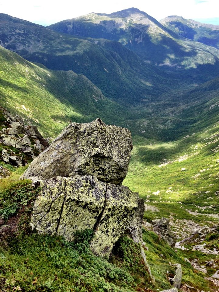
The Hut break ends, "only" 1.4 miles to go to the summit of Washington. They don't call Mt Washington "The Rock Pile" for nothing. The next 1.4 miles will bring us up a relatively steep, but a not killer upward slope of broken & jagged rock,created and layed to rest by millions of years of battering wind, rain, snow and ice, referred to by many as the worst weather in the world. But before we get into that we pass The Lake of The Clouds, a beautiful mountain lake resting between Mt's Monroe & Washington..
I posted the attached picture of the lake on facebook and someone commented, "It's not a lake, it's a giant mirror!" I mirror that thought!
 |
| The approach to the summit of Washington from lake of The Clouds (image by Peter Noonan) |
As we pass the lake and some interesting weather gear situated across from the lake, we begin the ascent toward the Summit of Washington. A very tired and beaten sign warns us we are entering an area known for the worst weather on earth. In both directions young, strong Sherpa-like Appalachian Mountain Club (AMC) employees cross our path. They are carrying huge, heavy and awkward wooden-framed packs, loaded with supplies, trash and big boxes, destined to be received at either the hut or the Mt Washington summit complex. Again I notice the sweat beginning to flow. The only sounds marking my steps are the clicking and clacking of my aluminum hiking sticks scraping the rock below and my deliberate attempt to maximize my intake of oxygen by exaggerating each breath. As we get closer to the summit, towers of weather and communication gear begin to appear.. larger and larger, combined with the rocky surface and eerie weather patterns swirling in and out, (seemingly coming from nowhere) and the dizzying effects of fatigue, the feel becomes sort of hyponotic and surreal, like you are walking toward some sort of science fictitious inter-planetary outpost. Then you pop out onto the summit complex grounds and immediately begin mingling with all sorts of people; people in-shape, out of shape, children, babies, grandmothers ,dogs and fellow hikers.. car, motorcycle & train tourists, clad in things like kilts, jeans, expensive hiking gear, expensive motorcycle gear, regular shorts, tight shorts and tee-shirts that say things like Northface, Seek The Peek, Harley Davidson , Dale Earnhardt, Red Sox, Yankees or Old Orchard Beach. It really is an eerie, Dream-like feeling. We make our way to the summit marker, stand in line behind a guy, a hiker. wearing a white wifebeater tee-shirt & sporting an old tattoo that I didn't bother to look at. He can't find his dog, so I tell him to go look for it and I'll hold his postion in the summit picture line. When he and his dog return he tells me he just completed his 48th 4,000 footer, we congratulate him. I snap his picture, he snaps ours and off we go to the combination observatory/snack bar/gift shop/museum/hiker enclave for some food and rest.
Chapter 2: The Summit
The 3 of us eat, Karen buys a slice of pizza & a Snickers bar to celebrate her well earned summit achievement. She's worked hard on both the treadmill and the trails preparing for this. Peter comes back with a slice of peperoni pizza, hot dog, bag of chips and a cola ( i can write a blog on that someday!). I eat my homemade pinto bean & chipole peeper hummus wrap and buy a cup of tomato soup. We finish up, separate the recyclables from the other trash, fill our empty water bottles with the coldest best tasting water on the planet and off we go to start our decent. It is now 12:30 pm.
Chapter 3: The Decent
 |
| Goofing with the Cog (image by Petwer Noonan) |
We decide to descend the mountain via the Jewell Trail. This trail is a longer (abut 5 miles) option than others and as it winds down the mountain it treats you to fantastic views of The Great Gulf and the northern Prezi's (Clay, Jefferson, Madison & Adams). But before we leave, we sight-see and goof around a little. I ham-up a hitchhiking photo-op with the Cog (thanks Dan for the idea), which brings out cameras and smiles to those riding the train. We pass the grave marker of Lize Bourne, the first woman to die on Mt Washington, and Peter & I compete to see who can get the best poser-money-shot. Below are the 2 finalist poser shots, I am partial to the one with me in it. However, I took the other one, so it's a win-win.:
 |
| Poser shot #1 (image by Peter Noonan) |
 |
| Poser shot #2 |
Here's where it got a little interesting. I will let Karen tell this part of the story as she posted it perfectly on Facebook:
"We encountered the two women at 12:30pm yesterday as we were beginning our hike down Mt Washington. They came up on the cog railroad and decided it was a lovely day for a hike down the mountain. In preparation for their 3.5 hour hike down they had nothing. Not one bottle of water, no food, no backpack, no polls and apparently no cell phone. Neil did advise them that it was a difficult 5 mile hike and that there were some very steep parts but they decided to hike anyway. Since only one woman was rescued I can only assume the other woman was smart enough to turn back at some point. Luckily she was not injured and nobody that was forced to rescue her was injured either. Trust me, they were not given any bad hiking advise. They were just stupid."
Attached is the link to the rescue article, which we weren't surprised to see on the next mornings news:
 |
| View of great Gulf, Jefferson, Madison & Adams |
 |
| Karen bids farewll to the summit of Washington |
Chapter 4: The After Party
The 3 of us descend, following the beautiful Jewell trail, following ruggid switchbacks and narrow trails from above treeline, into the trees. when the terrain became a little more hospitable, i decided to do a little trail running. We finally pop out of the woods at the Cog Railway base station and with that step, Karen officially notches her first assent of Mt Washington. We hoof it back about a 1/4 mile or so to our car (it's now 4:00pm) and proceed to drive to the Auto Road base camp for a wonderful celebration, catered by Harts Turkey farm, honoring those who help raise over $250,000 in the Seek The Peak Fundraiser for the continued weather-science work preformed by The Mt Washington Observatory. The awesomeness doesn't stop yet, the generosity of the sponsors was outstanding as raffle prizes of excellent quality were given away like candy. I did win a pair of Vasque hiking boots in one of the raffles, which made me even happier than i was when i arrived at the party, and that my friends means I was VERY happy!!
 |
| The end!!!! |
Post Commentary:
And so ended another in a long line of great & memorable days in New Hampshire's White Mountains. Mount Washington is a special place, If you are going to visit it by foot, car, motorcycle, train, ect, read about it's history, it will make your visit that much more enjoyable.
 |
| All is in tune (image by Peter Noonan) |


